
Desertification is the destruction of biological potential of the land which can ultimately lead to desert like conditions. These are the manifestations of the environmental deterioration in semi-arid and arid regions.
The causes include the loss of regenerative capacity of the soil resulting from (i) extreme depletion or absence of moisture or water, (ii) alkalinisation-salinisation, (iii) water logging and deep erosion that divests the soil of their nutrients.
Although climate is one of the most important factors, the abuse of land and over exploitation of its vegetation and water resources are primarily responsible for the expansion of deserts.
WORLD SCENARIO
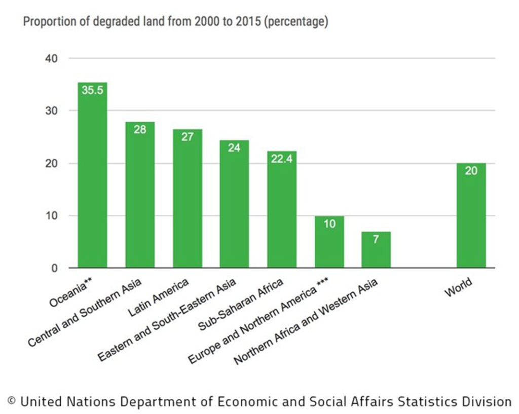
Drylands occupy approximately 40–41% of Earth’s land area and are home to more than 2 billion people. It has been estimated that some 10–20% of drylands are already degraded, the total area affected by desertification being between 6 and 12 million square kilometers, that about 1–6% of the inhabitants of drylands live in desertified areas, and that a billion people are under threat from further desertification.
More than one fifth of the population living in 63 countries of Asia and Africa are threatened with the consequences of the march of the desert at a rate of 600 million hectares per year. The land lost annually due to desertification is about equal to the land brought under irrigation each year.
In North Sudan, the Sahara desert has expanded by 100 km in the last 20 years. New areas in countries like Senegal, Ethiopia and Tunisia have been threatened with desertification.
Another major area that is being impacted by desertification is the Gobi Desert located in Northern China and Southern Mongolia. The Gobi Desert is the fastest expanding desert on Earth, as it transforms over 3,600 square kilometres of grassland into wasteland annually.
South America is another area vulnerable by desertification, as 25% of the land is classified as drylands and over 68% of the land area has undergone soil erosion as a result of deforestation and overgrazing. 27 to 43% of the land areas in Bolivia, Chile, Ecuador and Peru are at risk due to desertification. In Argentina, Mexico and Paraguay, greater than half the land area is degraded by desertification and cannot be used for agriculture.
In all about 20 million sq. km area (equal to the combined area of USA and Australia) is now on the brink of severe desertification. If this rate of desertification continues, one-third of the world’s cropland would disappear in the near future.
CAUSES OF DESERTIFICATION
a. Water Erosion:
Soil erosion through fluvial processes is one of the most important causes of desertification. Increased ploughing and destruction of vegetation cover for fuelwood, overgrazing and other destructive uses, have accelerated the erosion in recent decades.
b. Wind Erosion/Deposition:
The introduction of tractors for deep ploughing, instead of the traditional animal driven wooden plough, has increased the sand load manifold for the aeolian processes in large parts of the desert and has accelerated the mobility of sand. Increased destruction of the natural plant cover in grazing lands for fuel and fodder and enlarging the frontiers of cultivation to less suitable sandy areas are also the responsible factors.
c. Industrial Effluents:
In recent years industrial effluents have become a major source of land and water pollution. Use of toxic water for irrigation has also degraded the land.
d. Mining:
The area occupied by the mines is increasing constantly. The surface mining activity causes immediate degradation of land.
e. Vegetation Degradation:
One of the important reasons of desertification is destruction of natural vegetation. The common grazing lands around the villages are now some of the most severely degraded sites, as these have been highly exploited and neglected. Many good grazing lands have also been encroached upon for agriculture.
f. Climatic Changes:
At present the aridity is increasing and the atmospheric temperature is rising as a result of increase in dust, aerosols, hydrocarbons and carbon dioxide in the lower atmosphere and the reflection of heat from deforested land. This makes the threat of desertification very real in the dry arid and semi-arid tracts.
MEASURES TO CONTROL DESERTIFICATION
a. Preparation of a Desertification Hazard Map:
The first step towards controlling desertification is the preparation of desertification hazard map. This includes the identification of areas vulnerable to desertification on the basis of prevalent environmental stress and regular monitoring of changes occurring in the desert-prone eco-system.
b. Changes in Grazing Practices:
Livestock should be prevented from grazing freely in order to allow the soil to regenerate and nurture vegetation. The cattle should be permitted to graze only in the specially fenced reserves. Planting of fodder trees inside and around the fencing of the grazing land would save the pastures and would lead to growth of protective and beneficial vegetal cover on the loose soil.
c. Water Harvesting:
In this, the rainwater is gathered by converging channels on the hill slopes and diverted to settlement areas. Flood waters are also diverted. The stored water is covered with a film to prevent evaporation.
d. Sand Dune Stabilization:
Sand dune stabilisation include: (i) Protection of dunes from biotic interference, (ii) Development of micro windbreaks from the crest to the base of the dunes in the form of parallel or chessboard pattern and (iii) Reseeding of grass and creeper seed in between the micro windbreaks and transplanting of nursery-raised trees.
e. Shelterbelt Plantation:
If shelterbelts with 3-5 rows of trees are planted across the land in the wind direction, soil erosion can be minimized.
f. Aerial Seeding:
Due to sandy nature of the soil, the water holding capacity is very low, with the result that sowing of seeds needs to be completed within 2-3 days to favour germination. Conventional methods of afforestation are inadequate for revegetation of such a large and inaccessible tract having low moisture, erratic rainfall and lose sandy soil. Therefore, aerial seeding could be practised.
g. Silvipasture Systems:
This helps in reducing salinisation and wind erosion and thus increases productivity on long term basis, besides conserving resources and providing economic stability.
h. Minimum Tillage:
Tillage of agricultural land is necessary, particularly from the point of view of seed bed preparation, moisture conservation and weed control. Excessive tillage under dry conditions, however, exposes the soil to wind action.
i. Strip Cropping:
Strip cropping for wind erosion control is alternate plantation of erosion-susceptible and erosion tolerant crops, perpendicular to the prevailing wind direction. The main advantage of the system is that erosion tolerant strips reduce the velocity of the prevailing wind, trap sand particles and thereby control soil avalanching. Therefore, narrow strips are more effective in reducing wind erosion in lighter soils.
j. Judicious use of Irrigation Water:
Irrigation plays a significant role in arresting desertification through its effects in promoting the establishment and growth of vegetation. In highly sandy and dune covered areas, sprinkler system of irrigation could be effectively used for raising crops and other vegetation. This has been found to economize water and increase the production.
Global Efforts to Prevent Desertification
2021-2030 UN Decade on Ecosystem Restoration: This global initiative brings together Member States, local governments, academia, and the private sector to find sustainable solutions to restore the health of ecosystems, in which halting desertification is a key component.
The Bonn Challenge: The Bonn Challenge is a global goal to bring 150 million hectares of degraded and deforested landscapes into restoration by 2020 and 350 million hectares by 2030.
Goal 15 of Sustainable Development Goals (SDG), 2030: Protect, restore and promote sustainable use of terrestrial ecosystems, sustainably manage forests, combat desertification, and halt and reverse land degradation and halt biodiversity loss.
United Nations Convention to Combat Desertification (UNCCD): Adopted in 1994 UNCCD is a Convention to combat desertification and mitigate the effects of drought through national action programs that incorporate long-term strategies supported by international cooperation and partnership arrangements.
The World Day to Combat Desertification and Drought is a United Nations observance celebrated each year on 17 June.
Great Green Wall Initiative: The Great Green Wall or Great Green Wall for the Sahara and the Sahel is a project adopted by the African Union in 2007, initially conceived as a way to combat desertification in the Sahel region and hold back expansion of the Sahara desert, by planting a wall of trees stretching across the entire Sahel from Djibouti, Djibouti to Dakar, Senegal. The original dimensions of the “wall” were to be 15 km wide and 7,775 km long, but the program expanded to encompass nations in both northern and western Africa.
UNITED NATIONS CONVENTION TO COMBAT DESERTIFICATION (UNCCD)
• Established in 1994, UNCCD is the sole legally binding international agreement linking environment and development to sustainable land management.
• The UNCCD is particularly committed to a bottom-up approach, encouraging the participation of local people in combating desertification and land degradation.
• The United Nations Convention to Combat Desertification (UNCCD) is one of the Rio Conventions that focuses on desertification, land degradation and drought (DLDD).
• UNCCD with 197 Parties is a unique instrument that recognises land degradation as an important factor affecting some of the most vulnerable people and ecosystems in the world.
• The convention promotes sustainable land management (SLM) as solution to global challenges.https://www.unccd.int/
INDIAN SCENARIO
Status of Indian desertification
֍ The total area undergoing the process of land degradation in India is 105.48 million hectares, which constitutes 32.07 percentage of India’s total land area.
֍ 81.45 million hectares area of the country is under desertification (land degradation within drylands).
֍ In India the drylands, comprising the hot arid, semi-arid and the dry sub-humid climate zones, account for 203 million hectares or 61.9 per cent of the total geographical area.
֍ Ironically these regions are undergoing a steep rise in population, with attendant demands from the limited land and water resources, and attracting many new industries, which release toxic elements into its atmosphere, soil and water.
֍ The net result is degradation of more land, as well as a gradual deterioration of the production potentials of these climatically handicapped fragile regions.
֍ Soil erosion through fluvial processes affects large areas in the Saurashtra and Kuchchh uplands, and along the eastern margin of the Thar desert where the average annual rainfall varies from 350 to 500 mm.
֍ The Thar desert case study in the Luni-Development block revealed that the discharge potential of over 83 per cent of the wells had greatly dropped over a decade. Most of the wells, moreover, had been highly saline and irrigation with such water had wasted large tracts of land. Likewise excessive irrigation along Rajasthan Canal has caused water logging.
֍ Over exploitation of ground water in the dry zone as well as unplanned use of the surface water pose serious problems.
Control measures (major programmes)
India is a signatory to United Nations Convention to Combat Desertification (UNCCD). The National Action Programme for combating desertification was prepared in 2001 to take appropriate action in addressing the problems of desertification.
Some of the major programmes currently implemented that address issues related to land degradation and desertification are:
• Integrated Watershed Management Programme
• National Afforestation Programme
• National Mission for Green India
• The Mahatma Gandhi National Rural Employment Guarantee Scheme
• Soil Conservation in the Catchment of River Valley Project and Flood Prone River
• National Watershed Development Project for Rainfed Areas
• Desert Development Programme
• Fodder and Feed Development Scheme- component of Grassland Development including Grass Reserves, Command Area Development and Water Management programme etc.
Control measures (Works undertaken)
1. Serious research and development work to combat desertification of the Thar Desert has been going on for several decades. Remote sensing techniques have been utilized for delineating vulnerable areas, sand-piling and salinity encroachments and to monitor biotic disturbances.
2. The Central Arid Zone Research Institute (CAZRI), Jodhpur, has prepared maps of Rajasthan desert indicating the pattern of soil, sand form, vegetation, pattern of human activities and the resources potential of an area for development planning.
3. CAZRI has developed viable and feasible strategies for sand dune fixation, soil-conservation & pasture management, large areas are being covered by farm forestry, silvipastoral plantation, village fuel wood plantation and shelter-belt cum road-side & canal bank plantation.
4. Emphasis has been laid on high yielding forage grass and legumes, improved grassland and livestock production.
5. A number of technologies have been developed by CAZRI to improve the irrigation system.The drip irrigation system standardized at CAZRI for vegetable crops and orchards has not only increased production but it also made it possible to use saline water without serious hazards.
6. Early maturing high yielding seeds with low water requirements have been released by CAZRI for cultivation in North-West desert of India. These includes millet, minor millet, sorghum, moong, sesame (oil seed), etc.
7. A number of techniques for harvesting and conserving rain water are being used very successfully for raising orchards which have been developed by CAZRI to provide the farmers an assured income even in years of drought.
8. Better grazing practices have been introduced through DDAP and DDP and in the Rajasthan Canal Command Areas which have helped in the increase of livestocks.
Conclusion
Desertification is a silent, invisible crisis that is destabilizing communities on a global scale. The effects of desertification are increasingly felt globally as victims turn into refugees, internally displaced people and forced migrants or they turn to radicalization, extremism or resource-driven wars for survival.
If we are to restore peace, security and international stability in a context where changing weather events are threatening the livelihoods of more and more people, survival options are declining and state capacities are overburdened, then more should be done to combat desertification, reverse land degradation and mitigate the effects of drought. Otherwise, many small-scale farmers and poor, land-dependent communities face two choices: fight or flight.
In order to combat desertification, it is essential to have comprehensive, phased action plan of development with clear priorities backed by people’s participation and political and administrative will.
PRACTICE QUESTIONS
UPSC MAINS
QUES . The process of desertification does not have climate boundaries. Justify with examples. (Answer in 150 words) 10 marks. UPSC MAINS 2020 GS PAPER I
UPSC PRELIMS
QUES . What is/are the importance/importances of the ‘United Nations Convention to Combat Desertification’? UPSC 2016
1. It aims to promote effective action through innovative national programmes and supportive international partnerships.
2. It has a special/particular focus on South Asia and North Africa regions, and its Secretariat facilitates the allocation of major portion of financial resources to these regions.
3. It is committed to bottom-up approach, encouraging the participation of local people in combating the desertification.
Select the correct answer using the code given below.
(a) 1 only
(b) 2 and 3 only
(c) 1 and 3 only
(d) 1, 2 and 3
(c)
QUES . Which of the following statements is/ are correct ? CDS 2019
1 . India is a signatory to the United Nations Convention to Combat Desertification (UNCCD)
2 . Ministry of Home Affairs is the nodal Ministry in the Government of India for the UNCCD.
Select the correct answer using the code given below :
(a) 1 only
(b) 2 only
(c) Both 1 and 2
(d) Neither 1 nor 2
(a)
Fantastic 😍
Excellent work it’s so helpful 🤩
Great work,keep going
Thank you sir, it’s very helpful
Excellent sir really helpful and easy to understand
Very excellent sir