What is UNCLOS?
The United Nations Convention on the Law of the Sea (UNCLOS), also called the Law of the Sea Convention or the Law of the Sea treaty, is the international agreement that resulted from the third United Nations Conference on the Law of the Sea (UNCLOS III), which took place between 1973 and 1982.
The Law of the Sea Convention defines the rights and responsibilities of nations with respect to their use of the world’s oceans, establishing guidelines for businesses, the environment, and the management of marine natural resources.
When UNCLOS came into force?
UNCLOS came into force in 1994.
How many parties are there in UNCLOS?
As of June 2023, 168 countries and the European Union have joined in the Convention.
What is ‘freedom of the seas’ concept?
UNCLOS replaces the older ‘freedom of the seas’ concept, dating from the 17th century: national rights were limited to a specified belt of water extending from a nation’s coastlines, usually 3 nautical miles.
Limit of various areas set by UNCLOS III

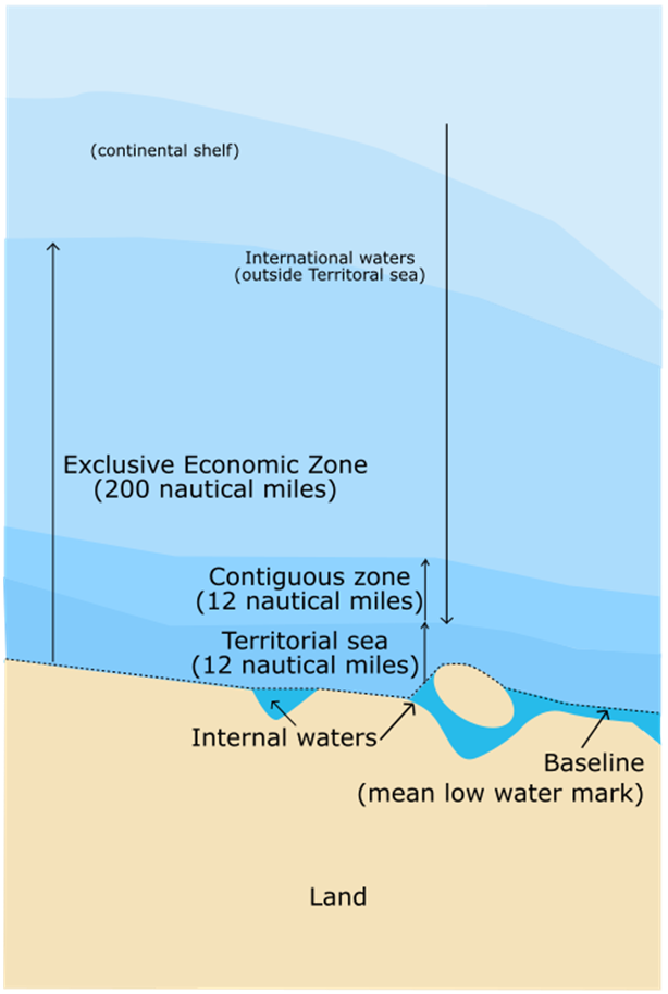
The convention set the limit of various areas, measured from a carefully defined baseline.
Normally, a sea baseline follows the low-water line, but when the coastline is deeply indented, has fringing islands or is highly unstable, straight baselines may be used.
The areas are as follows:
Internal waters
Covers all water and waterways on the landward side of the baseline. The coastal state is free to set laws, regulate use, and use any resource. Foreign vessels have no right of passage within internal waters.
Territorial waters
Out to 12 nautical miles (22 kilometres) from the baseline, the coastal state is free to set laws, regulate use, and use any resource.
Vessels are given the right of innocent passage through any territorial waters.
“Innocent passage” is defined by the convention as passing through waters in an expeditious and continuous manner, which is not “prejudicial to the peace, good order or the security” of the coastal state.
Fishing, polluting, weapons practice, and spying are not “innocent”, and submarines and other underwater vehicles are required to navigate on the surface and to show their flag.
Nations can also temporarily suspend innocent passage in specific areas of their territorial seas, if doing so is essential for the protection of their security.
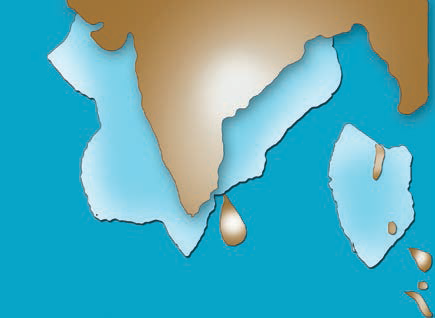
Archipelagic waters
A baseline is drawn between the outermost points of the outermost islands, subject to these points being sufficiently close to one another. All waters inside this baseline are designated Archipelagic Waters.
The state has sovereignty over these waters (like internal waters), but subject to existing rights including traditional fishing rights of immediately adjacent states.
Foreign vessels have right of innocent passage through archipelagic waters (like territorial waters).
Contiguous zone
Beyond the 12-nautical-mile (22 km) limit, there is a further 12 nautical miles (22 km) from the territorial sea baseline limit, the contiguous zone, in which a state can continue to enforce laws in four specific areas: customs, taxation, immigration and pollution.

Exclusive economic zones (EEZs)
These extend 200 nautical miles (370 kilometres) from the baseline. Within this area, the coastal nation has sole exploitation rights over all natural resources.
Foreign nations have the freedom of navigation and overflight, subject to the regulation of the coastal states.
Foreign states may also lay submarine pipes and cables.

Continental shelf
The continental shelf is defined as the natural prolongation of the land territory to the continental margin’s outer edge, or 200 nautical miles (370 km) from the coastal state’s baseline, whichever is greater.
A state’s continental shelf may exceed 200 nautical miles (370 km) until the natural prolongation ends. However, it may never exceed 350 nautical miles (650 kilometres) from the baseline.
Coastal states have the right to harvest mineral and non-living material in the subsoil of its continental shelf, to the exclusion of others.
Coastal states also have exclusive control over living resources “attached” to the continental shelf, but not to creatures living in the water column beyond the exclusive economic zone.
Other important provisions
Aside from its provisions defining ocean boundaries, the convention establishes general obligations for safeguarding the marine environment and protecting freedom of scientific research on the high seas
It also creates an innovative legal regime for controlling mineral resource exploitation in deep seabed areas beyond national jurisdiction, through an International Seabed Authority and the Common heritage of mankind principle.
Landlocked states are given a right of access to and from the sea, without taxation of traffic through transit states.
PRACTICE QUESTIONS
QUES . With reference to the United National Convention on the Law of Sea, consider the following statements: UPSC 2022
1. A coastal state has the right to establish the breadth of its territorial sea up to a limit not exceeding 12 nautical miles, measured from baseline determined in accordance with the convention.
2. Ships of all states, whether coastal or land-locked, enjoy the right of innocent passage through the territorial sea.
3. The Exclusive Economic Zone shall not extend beyond 200 nautical miles from the baseline from which the breadth of the territorial sea is measured.
Which of the statements given above are correct?
(a) 1 and 2 only
(b) 2 and 3 only
(c) 1 and 3 only
(d) 1, 2 and 3
(d)
QUES . India’s territorial limit extends towards the sea up to: CDS 2021
(a) 10 nautical miles
(b) 12 nautical miles
(c) 14 nautical miles
(d) 15 nautical miles
(b)
QUES . Which one of the following is not an exclusive right of the concerned coastal nations over Exclusive Economic Zone (EEZ)? CDS 2018
(a) Survey and exploitation of mineral resources of ocean deposits
(b) Exploitation of marine water energy and marine organisms including fishing
(c) Conservation and management of marine resources
(d) Navigation of ships and laying down submarine cables
(d)
