
Yangtze or Yangzi or Changjiang River
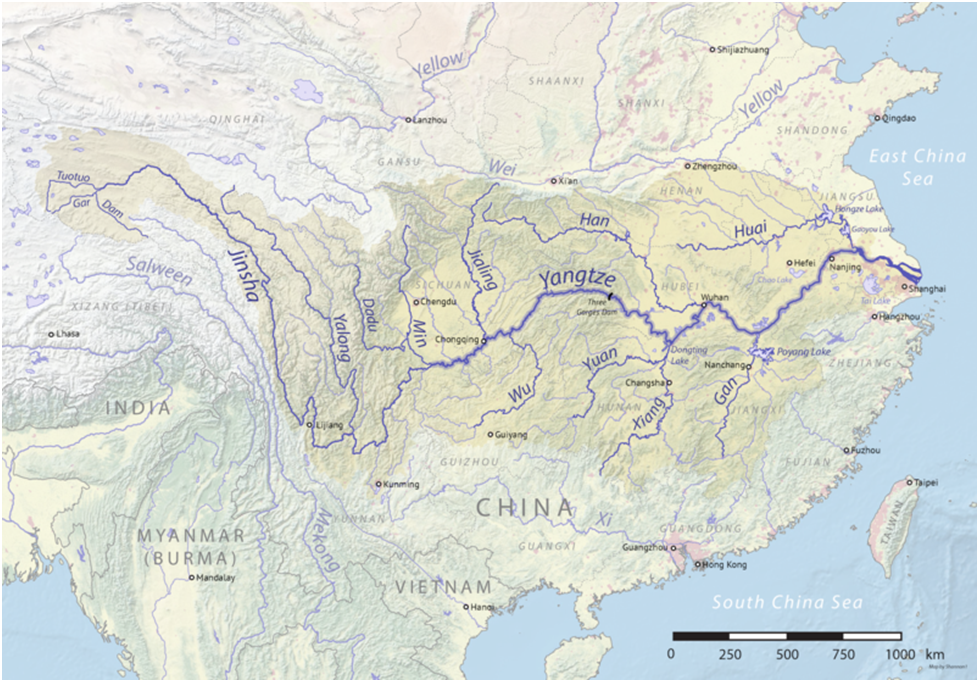
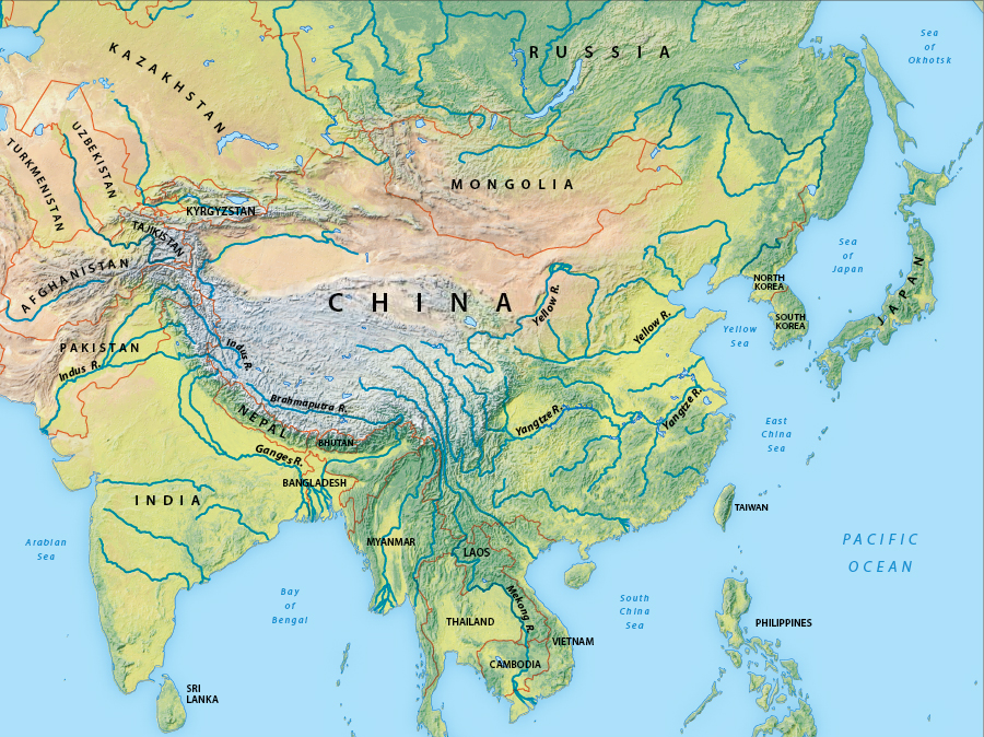
The Yangtze, Yangzi or Changjiang is the longest river in Eurasia, the third-longest in the world, and the longest in the world to flow entirely within one country.
It rises at Jari Hill in the Tanggula Mountains of the Tibetan Plateau and flows 6,300 km in a generally easterly direction to the East China Sea.
It is the fifth-largest primary river by discharge volume in the world.
Its drainage basin comprises one-fifth of the land area of China, and is home to nearly one-third of the country’s population.
The prosperous Yangtze Delta generates as much as 20% of China’s GDP.
The Three Gorges Dam on the Yangtze is the largest hydro-electric power station in the world that is in use.
It was the home of the now extinct Yangtze river dolphin (or baiji).
Lake Poyang, the biggest freshwater lake in China, merges into the river.
Cities : Wuhan, Shanghai, etc.
Yellow River
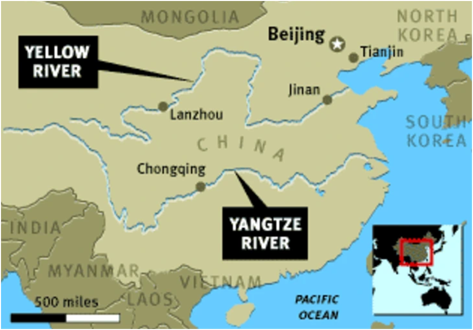
The Yellow River is the second-longest river in China, after the Yangtze River, and the sixth-longest river system on Earth at the estimated length of 5,464 km .
Originating in the Bayan Har Mountains, it empties into the Bohai Sea.
The Yellow River basin was the birthplace of ancient Chinese civilization.
Its yellow sediments are carried downstream from the Loess Plateau.
The river experiences frequent devastating floods and course changes produced by the continual elevation of the river bed.
Mekong River
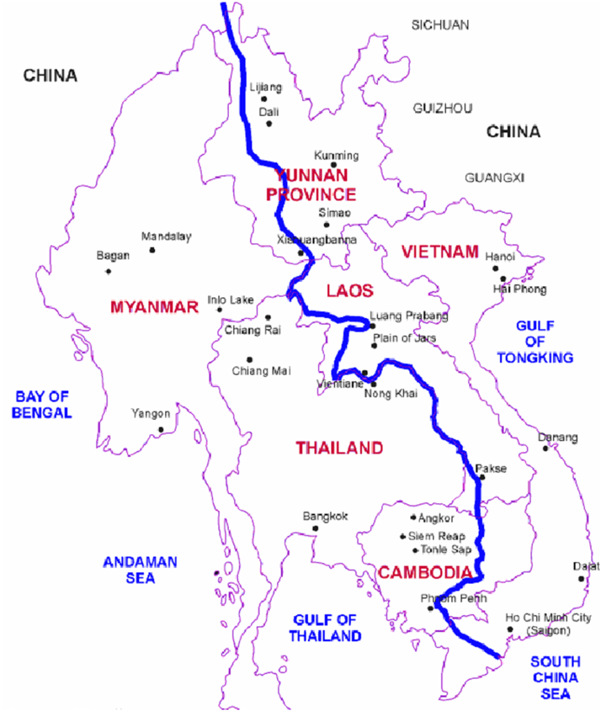
Mekong River is a trans-boundary river in East Asia and Southeast Asia.
It is the world’s twelfth-longest river and the third-longest in Asia with an estimated length of 4,909 km.
From its headwaters in the Tibetan Plateau, the river runs through Southwest China, Myanmar, Laos, Thailand and Cambodia before entering the South China Sea via a complex delta system in Vietnam.
Lena river
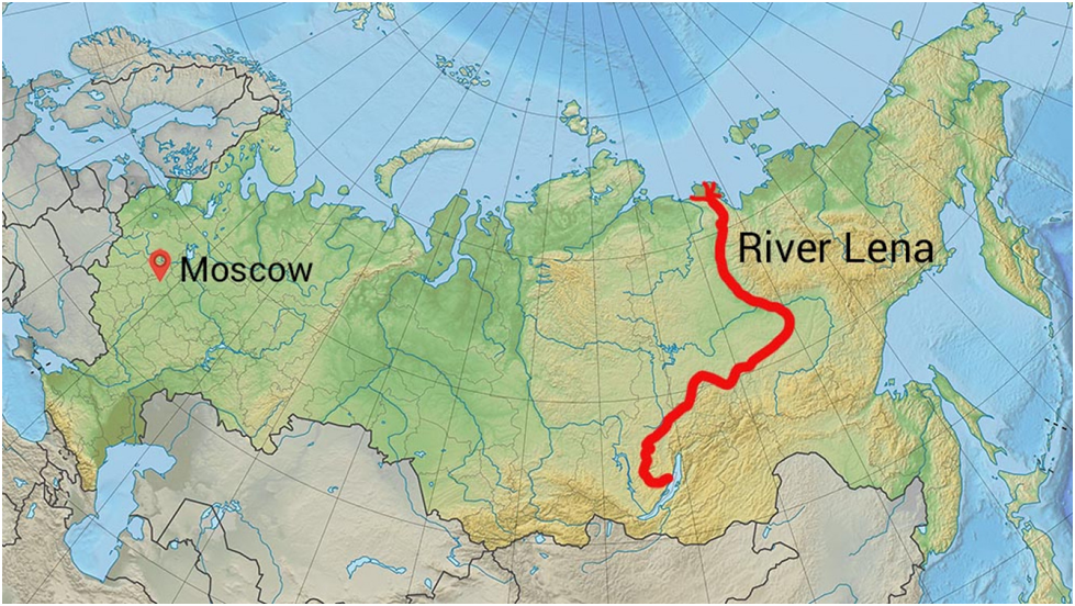
The Lena is a river in the Russian Far East, and is the easternmost of the three great Siberian rivers that flow into the Arctic Ocean (the other two being the Ob and the Yenisey).
The Lena is the eleventh-longest river in the world, and the longest river entirely within Russia, with a length of 4,294 km.
Originating at an elevation of 1,640 meters at its source in the Baikal Mountains south of the Central Siberian Plateau, 7 kilometres west of Lake Baikal, the Lena flows nearly due north and ends in the Laptev Sea, a division of the Arctic Ocean.
Irtysh River
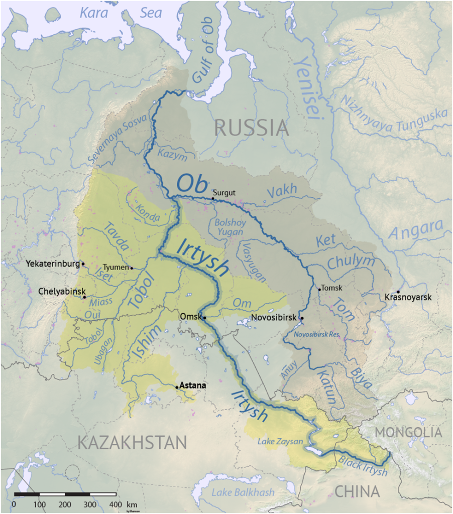
The Irtysh is a river in Russia, China, and Kazakhstan. It is the chief tributary of the Ob and is also the longest tributary river in the world.
The river’s source lies in the Mongolian Altai.
The Ob-Irtysh system forms a major drainage basin in Asia, encompassing most of Western Siberia and the Altai Mountains.
Brahmaputra River

The Brahmaputra is a trans-boundary river which flows through Tibet (China), Northeastern India, and Bangladesh.
It is known as Brahmaputra in Assamese, Yarlung Tsangpo in Tibetan, the Siang/Dihang River in Arunachali, and Jamuna River in Bengali.
It is the 9th largest river in the world by discharge, and the 15th longest (3,969 km).
It originates from Chemayungdung glacier in the Manasarovar lake region, near Mount Kailash, on the northern side of the Himalayas in Tibet where it is known as the Yarlung Tsangpo River.
The Brahmaputra flows along southern Tibet to break through the Himalayas in great gorges and enters India in Arunachal Pradesh. Then it flows southwest through the Assam Valley as the Brahmaputra and south through Bangladesh as the Jamuna.
In the vast Ganges Delta, it merges with the Ganges, popularly known as the Padma in Bangladesh, and becomes the Meghna and ultimately empties into the Bay of Bengal.
It is a classic example of a braided river and is highly susceptible to channel migration and avulsion.
It is one of the few rivers in the world that exhibits a tidal bore.
Bridges on Brahmaputra River in India
Naranarayan Setu near Bongaigaon in Assam ; Kolia Bhomora Setu near Tezpur in Assam; Bogibeel Bridge near Dibrugarh in Assam (longest on Brahmaputra River), etc.
Cities located on the banks of Brahmaputra River in India
Dibrugarh, Jorhat, Tezpur, Guwahati, Dhubri, etc.
Tributaries of Brahmaputra River in India
Lohit, Nao Dihing, Buri Dihing, Disang, Dhansiri, Kameng, Manas, Teesta, Subansiri, Sonkosh, etc.
Ob River
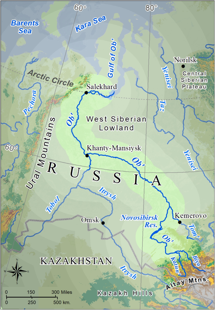
The Ob is a major river in Russia. It is in western Siberia, and with its tributary the Irtysh forms the world’s seventh-longest river system, at 5,410 kilometres.
The Ob forms at the confluence of the Biya and Katun which have their origins in the Altai Mountains.
It is the westernmost of the three great Siberian rivers that flow into the Arctic Ocean (the other two being the Yenisei and the Lena).
The Gulf of Ob is the world’s longest estuary.
Indus River
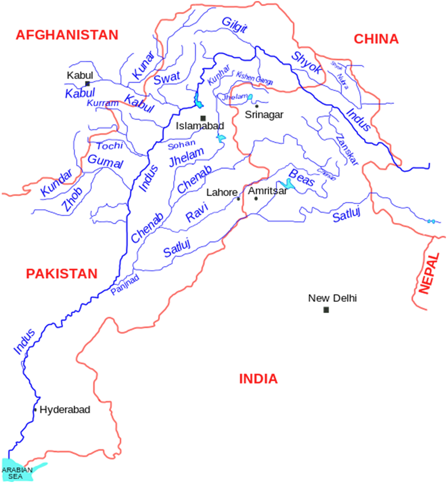
The Indus is a transboundary river of Asia and a trans-Himalayan river of South and Central Asia.
The 3,120 km river rises in mountain springs northeast of Mount Kailash in Western Tibet, flows northwest through the disputed region of Kashmir, bends sharply to the left after the Nanga Parbat massif, and flows south-by-southwest through Pakistan, before emptying into the Arabian Sea near the port city of Karachi.
Its left-bank tributary in Ladakh is the Zanskar River, and its left-bank tributary in the plains is the Panjnad River which is formed by the successive confluences of the five Punjab rivers, namely the Chenab, Jhelum, Ravi, Beas, and Sutlej rivers.
Its principal right-bank tributaries are the Shyok, Gilgit, Kabul, Kurram, and Gomal rivers.
The northern part of the Indus Valley, with its tributaries, forms the Punjab region of South Asia, while the lower course of the river ends in a large delta in the southern Sindh province of Pakistan.
Indus is an antecedent river, meaning that it existed before the Himalayas and entrenched itself while they were rising.
Yenisey River
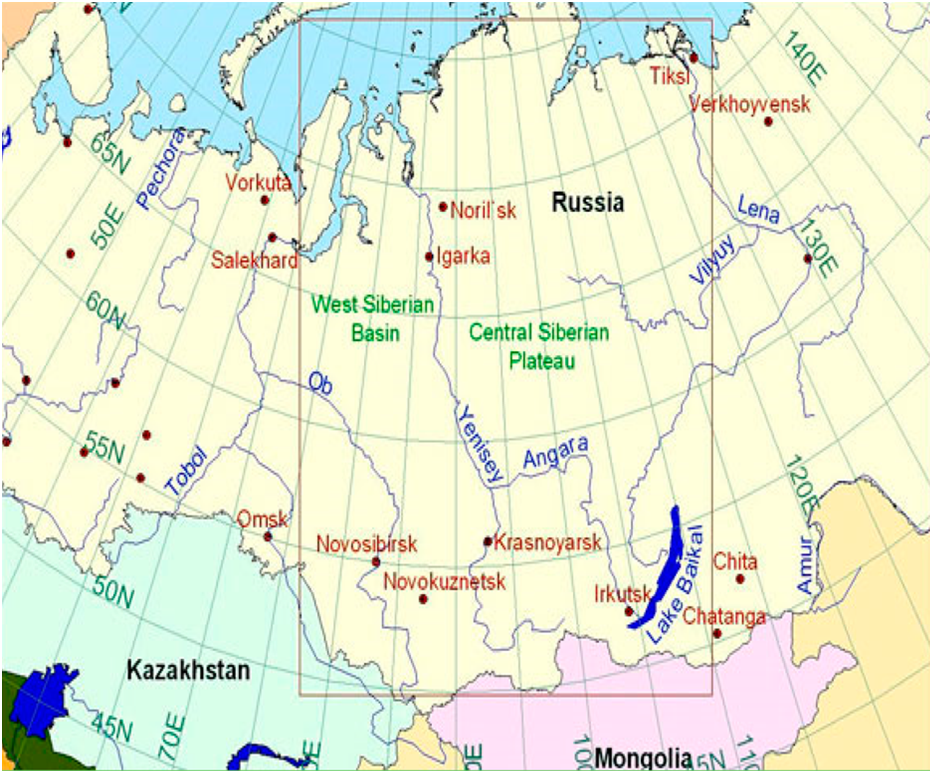
The Yenisey is the fifth-longest river system in the world, and the largest to drain into the Arctic Ocean.
Rising in in Mongolia, it follows a northerly course through Lake Baikal before draining into the Yenisey Gulf in the Kara Sea.
The Yenisey divides the Western Siberian Plain in the west from the Central Siberian Plateau to the east; it drains a large part of central Siberia.
It is the central one of three large Siberian rivers that flow into the Arctic Ocean (the other two being the Ob and the Lena).
Ganges River
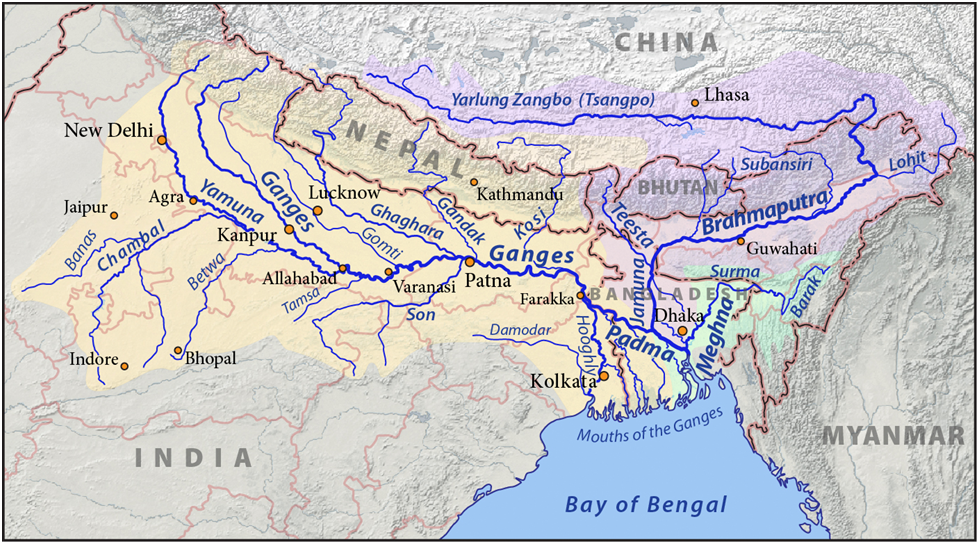
The Ganges is a trans-boundary river of Asia which flows through India and Bangladesh. The 2,525 km river rises in the western Himalayas in Uttarakhand.
It flows south and east through the Gangetic plain of North India, receiving the right-bank tributary, the Yamuna, which also rises in the western Indian Himalayas, and several left-bank tributaries from Nepal that account for the bulk of its flow.
In West Bengal a feeder canal taking off from its right bank diverts 50% of its flow southwards, artificially connecting it to the Hooghly River.
The Ganges continues into Bangladesh, its name changing to the Padma. It is then joined by the Jamuna, the lower stream of the Brahmaputra, and eventually the Meghna, forming the major estuary of the Ganges Delta, and emptying into the Bay of Bengal.
The Ganges–Brahmaputra–Meghna system is the second-largest river on earth by discharge.
The river’s drainage basin covers parts of four countries, India, Nepal, China, and Bangladesh; eleven states, Himachal Pradesh, Uttarakhand, Uttar Pradesh, Madhya Pradesh, Chhattisgarh, Bihar, Jharkhand, Punjab, Haryana, Rajasthan, West Bengal, and the Union Territory of Delhi.
The river’s source is usually assumed to be the source of the Bhagirathi River, Gangotri Glacier at Gomukh and its mouth being the mouth of the Meghna River on the Bay of Bengal.
The main stem of the Ganges begins at the town of Devprayag, at the confluence of the Alaknanda, which is the source stream in hydrology on account of its greater length, and the Bhagirathi, which is considered the source stream in all of Hindu mythology.
The Ganges is a lifeline to tens of millions of people who live in its basin and depend on it for their daily needs.
It has been important historically, with many former provincial or imperial capitals such as Pataliputra, Kannauj, Sonargaon, Dhaka, Bikrampur, Kara, Munger, Kashi, Patna, Hajipur, Delhi, Bhagalpur, Murshidabad, Baharampur, Kampilya, and Kolkata located on its banks or the banks of tributaries and connected waterways.
The river is home to critically endangered species such as the gharial and South Asian river dolphin.
The Ganges is the most sacred river to Hindus. It is worshipped as the goddess Ganga in Hinduism.
The Ganges is threatened by severe pollution. This not only poses a danger to humans but also to many species of animals. The levels of fecal coliform bacteria from human waste in the river near Varanasi are more than 100 times the Indian government’s official limit.
Major left-bank tributaries include the Gomti River, Ghaghara River, Gandaki River and Kosi River; major right-bank tributaries include the Yamuna River, Son River, Punpun and Damodar.
Dams and barrages
A major barrage at Farakka was opened on 21 April 1975, It is located close to the point where the main flow of the river enters Bangladesh.
Tehri Dam was constructed on Bhagirathi River, a tributary of the Ganges. It is located 1.5 km downstream of Ganesh Prayag, the place where Bhilangana meets Bhagirathi.
Bansagar Dam was built on the Sone River, a tributary of the Ganges.
Amur River
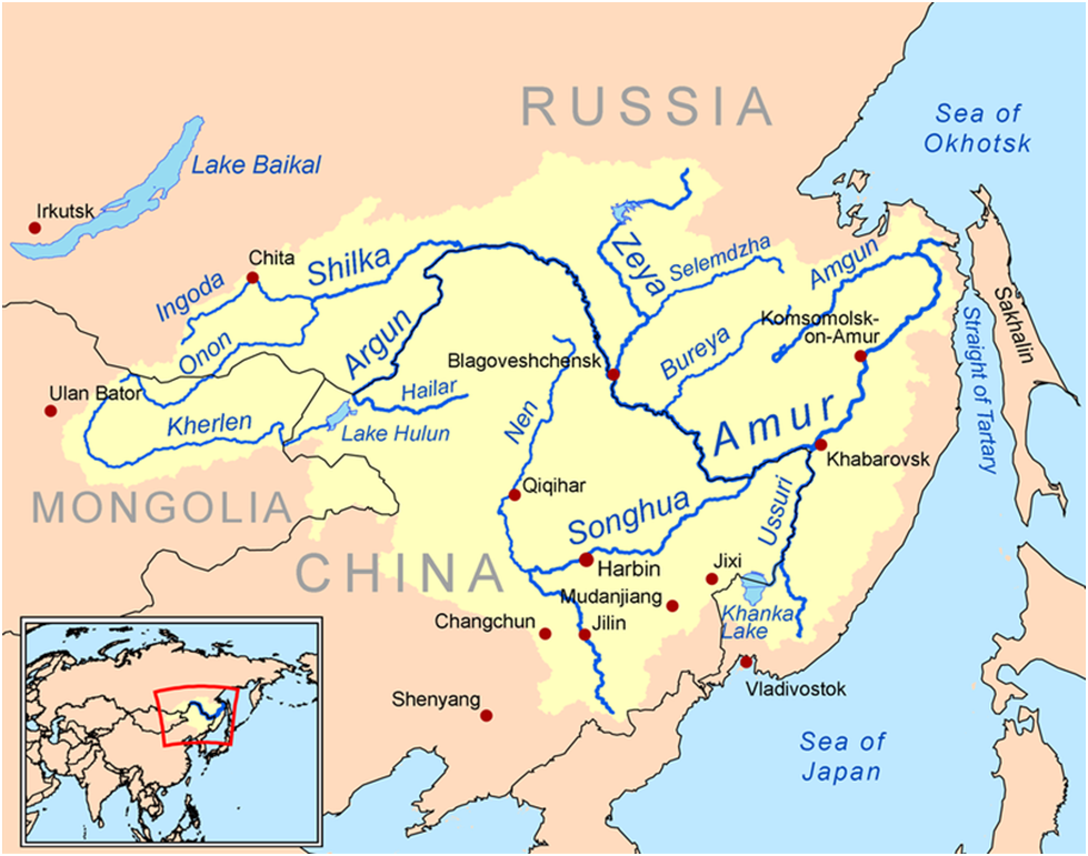
The Amur River is a perennial river in Northeast Asia, forming the natural border between the Russian Far East and Northeast China .
The Amur proper is 2,824 km long. It is the world’s tenth longest river.
Salween River
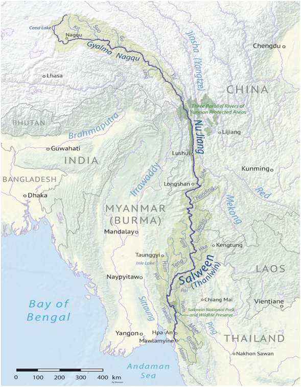
The Salween is a Southeast Asian river, about 3,289 kilometres long, flowing from the Tibetan Plateau south into the Andaman Sea.
The Salween flows primarily within southwest China and eastern Myanmar, with a short section forming the border of Myanmar and Thailand.
Euphrates River
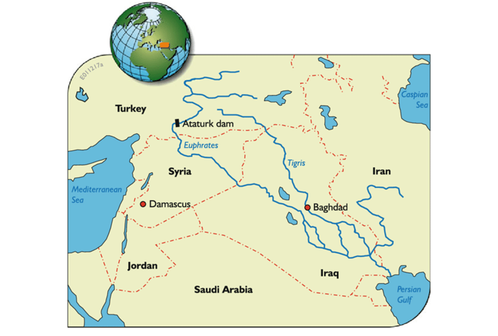
The Euphrates is the longest and one of the most historically important rivers of Western Asia.
Together with the Tigris, it is one of the two defining rivers of Mesopotamia (lit. ’the land between the rivers’).
Originating in Turkey, the Euphrates flows through Syria and Iraq to join the Tigris in the Shatt al-Arab in Iraq, which empties into the Persian Gulf.
The Euphrates is the longest river in Western Asia at about 2,780 km with a drainage area of 440,000 km2 that covers six countries.
Tigris River
For Tigris River map refer to the above figure.
The Tigris is the eastern of the two great rivers that define Mesopotamia, the other being the Euphrates.
The river flows south from the mountains of the Taurus in Turkey, then through the Syrian and Arabian Deserts, emptying into the Persian Gulf.
Irrawaddy River
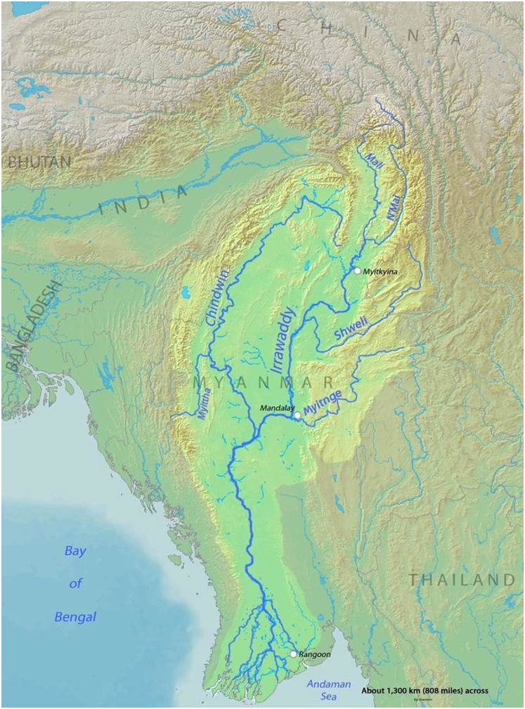
The Irrawaddy River is the largest river in Myanmar.
Originating from the confluence of the N’mai and Mali rivers in southeast Tibet, it flows from north to south before emptying through the Irrawaddy Delta in the Ayeyarwady Region into the Andaman Sea.
Its drainage basin of about 404,000 square kilometres covers 61% of the land area of Myanmar, and contains five of its largest cities.
Amu Darya
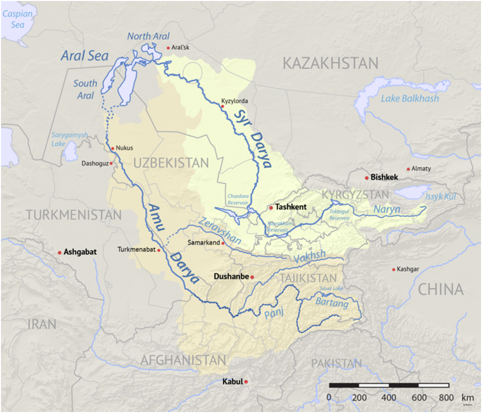
The Amu Darya also called the Amu, the Amo, and historically the Oxus is a major river in Central Asia, which flows through Tajikistan, Turkmenistan, Uzbekistan and Afghanistan.
Rising in the Pamir Mountains, north of the Hindu Kush, the Amu Darya is formed by the confluence of the Vakhsh and Panj rivers on the border between Afghanistan and Tajikistan, and flows from there north-westwards into the southern remnants of the Aral Sea.
In its upper course, the river forms part of Afghanistan’s northern border with Tajikistan, Uzbekistan, and Turkmenistan.
Syr Darya
For Syr Darya River map refer to the above figure.
The Syr Darya is a river in Central Asia.
It originates in the Tian Shan Mountains in Kyrgyzstan and eastern Uzbekistan and flows for 2,256.25 kilometres west and north-west through Uzbekistan and southern Kazakhstan to the northern remnants of the Aral Sea.
It is the northern and eastern of the two main rivers in the endorheic basin of the Aral Sea, the other being the Amu Darya.
Must read: Important Rivers of Africa
External link: https://www.wbcsd.org/Overview/Panorama/Articles/Improving-the-health-of-Asia-s-rivers-will-improve-the-health-of-the-continent