

Nile River

Approx. Length (km) : 6,650
Source : Lake Victoria, Africa
Outflow : Mediterranean Sea
Countries : Egypt, Sudan, South Sudan, Ethiopia, Uganda, Democratic Republic of the Congo, Kenya, Tanzania, Rwanda, Burundi
Major cities : Jinja, Juba, Khartoum, Cairo
Major Dams : Aswan High Dam in Egypt, Sennar Dam in Sudan on the Blue Nile, Grand Ethiopian Renaissance Dam (GERD) on Blue Nile River in Ethiopia, Owen Falls Dam (now the Nalubaale Dam) on the Victoria Nile in Uganda.
Lake Nasser is a reservoir on the Nile River, in Upper Egypt and northern Sudan. It was created by the impounding of the Nile’s waters by the Aswan High Dam.
The Nile is the longest river in Africa and has historically been considered the longest river in the world.
The Nile has two major tributaries – the White Nile and the Blue Nile. The White Nile is longer and rises in the Great Lakes region. It begins at Lake Victoria and flows through Uganda and South Sudan. The Blue Nile begins at Lake Tana in Ethiopia and flows into Sudan from the southeast. The two rivers meet at the Sudanese capital of Khartoum.
It is called the father of African rivers.
For more information on Nile River refer https://fotisedu.com/nile-river-source-outflow-dams-and-cities/
Congo (Zaire) River

Source : Lualaba River
Mouth : Atlantic Ocean
Length : 4,700 km
The Congo River formerly also known as the Zaire River, is the second-longest river in Africa, shorter only than the Nile, as well as the third-largest river in the world by discharge volume, following the Amazon and Ganges rivers.
It is the world’s deepest recorded river, with measured depths of around 220 m.
The Congo-Lualaba-Chambeshi River system has an overall length of 4,700 km , which makes it the world’s ninth-longest river.
The Chambeshi is a tributary of the Lualaba River, and Lualaba is the name of the Congo River upstream of Boyoma Falls, extending for 1,800 km.
It is the only major river to cross the Equator twice.
The Congo Basin has a total area of about 4,000,000 km2 , or 13% of the entire African landmass.
The Congo River is the most powerful river in Africa.
The entire Congo Basin accounts for 13 percent of global hydropower potential.
Dam : Inga dams
Niger River

Its source is in the Guinea Highlands in south-eastern Guinea near the Sierra Leone border.
It discharges through a massive delta, known as the Niger Delta, into the Gulf of Guinea in the Atlantic Ocean.
The Niger River is the main river of West Africa, extending about 4,180 km.
The Niger is the third-longest river in Africa, exceeded by the Nile and the Congo River.
Its main tributary is the Benue River.
Dams : Kainji Dam, Shiroro Dam, Zungeru Dam, and Jebba Dam.
Zambezi River

The Zambezi is the fourth-longest river in Africa, the longest east-flowing river in Africa and the largest flowing into the Indian Ocean from Africa.
The 2,574-kilometre-long river rises in Zambia and flows along the border between Zambia and Zimbabwe to Mozambique, where it crosses the country to empty into the Indian Ocean.
The Zambezi’s most noted feature is Victoria Falls. Its other falls include the Chavuma Falls at the border between Zambia and Angola, and Ngonye Falls near Sioma in western Zambia.
The two main sources of hydroelectric power on the river are the Kariba Dam, which provides power to Zambia and Zimbabwe, and the Cahora Bassa Dam in Mozambique.
Ubangi (Oubangui) River

Length 1,060 kilometres
The Ubangi River is the largest right-bank tributary of the Congo River in the region of Central Africa.
It begins at the confluence of the Mbomou and Uele Rivers
It forms the border between Central African Republic (CAR) and Democratic Republic of the Congo.
Kasai River

Length 2,153 km
The Kasai River is a left bank tributary of the Congo River, located in Central Africa.
The river begins in central Angola.
Diamonds are found in it. Around 60% of diamonds in Belgium go from Kasai river for cutting and shaping.
Orange River

The Orange River is a river in Southern Africa.
It is the longest river in South Africa.
With a total length of 2,432 km.
It rises in the Drakensberg mountains in Lesotho, flowing westwards through South Africa to the Atlantic Ocean.
The river forms part of the international borders between South Africa and Lesotho and between South Africa and Namibia.
The Orange River plays an important role in the South African economy by providing water for irrigation and hydroelectric power.
Limpopo River

The Limpopo River rises in South Africa and flows generally eastward through Mozambique to the Indian Ocean.
The river is approximately 1,750 kilometres long.
The Limpopo is the second largest river in Africa that drains to the Indian Ocean, after the Zambezi River.
At the confluence of the Marico River and the Crocodile River, the name becomes the Limpopo River.
Senegal River

Length 1,086 km
Mouth : Atlantic Ocean
Much of its length marks part of the border between Senegal and Mauritania.
Volta River
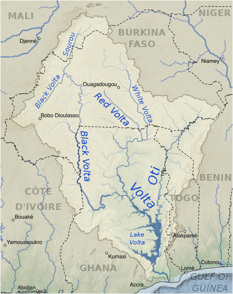
The Volta River is the main river system in the West African country of Ghana.
It flows south into Ghana from the Bobo-Dioulasso highlands of Burkina Faso.
The main parts of the river are the Black Volta, the White Volta, and the Red Volta.
Black Volta forms the international borders between the Ivory Coast, Ghana, and Burkina Faso.
The Volta empties into the Atlantic Ocean at the Gulf of Guinea.
The Volta River has been dammed at Akosombo for the purpose of generating hydroelectricity. The reservoir named Lake Volta is the largest man-made reservoir by area in the world. Akosombo Dam, also known as the Volta Dam, is on the Volta River in southeastern Ghana.