
Flash floods are defined as sudden floods caused by extreme rainfall events. Flash floods usually occur in a very short span of time usually less than six hours, which makes them extremely unpredictable and disastrous.
Must read: Flash Floods : Definition, Causes, Determinants, Forecasting, Impacts and Mitigation
Flash floods occur every year during the summer monsoon season in India, causing substantial damage to agriculture, infrastructure, and human life. The rising frequency of flash floods and substantial economic losses underscore the need to reinforce the flash flood preparedness across the nation.
Flash Flood Hotspots in India
Flash flood hotspots are mainly centered in Himalayas, West Coast, and Central India. Usually, geomorphological factors drive the flash floods in the Himalayas. Whereas, in the West Coast and Central India, flash floods are driven by the hydrological factors (high flashiness) of sub-basins (part of large river basins). This means that their water levels quickly reach the peak after a heavy rainfall event.
Several non-flash flood prone basins have experienced a significant increase in extreme precipitation frequency and intensity, highlighting that the warming climate can lead to newer flash flood hotspots in the future.
Recent Flash Flood Incidents in India
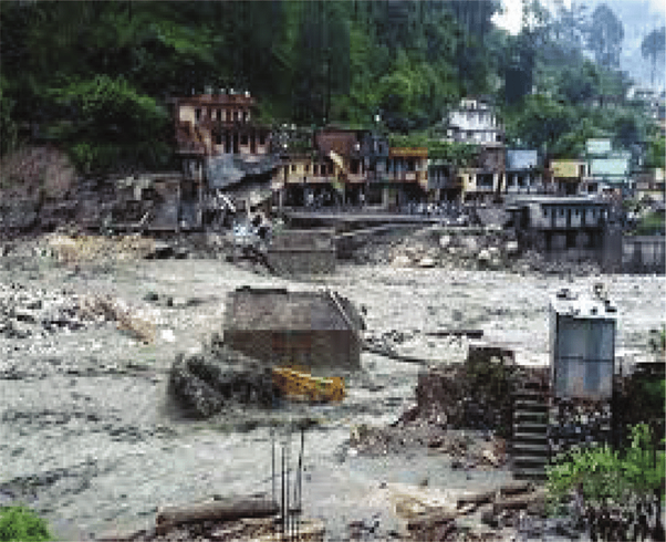
Several river basins and urban areas (Mumbai, 2005; Leh, 2010; Uttarakhand, 2013; Jammu and Kashmir, 2014; Chennai, 2015; Kerala, 2018; Bihar, 2019; Hyderabad, 2020; Assam, Meghalaya and Arunachal Pradesh, 2022; Assam and Kerala, 2024; Himachal Pradesh, 2025) experienced flash floods in the past decades, which severely impacted infrastructure and agriculture in India.
The low-lying river basins in India are highly susceptible to flash floods. The occurrences of high intensity rainfall in a short duration causing flash floods are on the rise even in rainfall scarce regions, such as semi-arid region of western India.
What are the triggering factors for flash floods in India?
The combination of extreme precipitation and wet antecedent conditions trigger most (~ 3/4th) flash floods while the remaining (~1/4th) are solely driven by extreme precipitation. If the ground is already wet before a heavy rainfall event, chances are the soil would be saturated or near saturated, which can lead to instant runoff. This increases the risk of flash floods.
Factors that attribute to the occurrence of flash floods in India
The combination of meteorological, geomorphological, and anthropogenic factors attribute to the occurrence of flash floods. The intense rainfall associated with tropical cyclones and the summer monsoon is a primary driver of flash floods.
An extreme rainfall event leads to immediate flash floods (within six hours) only 23% of the time. Usually, it is the prolonged (multi-day) low-intensity and high-intensity rainfall which results in these floods.
Saturated soil or impervious surface exacerbates flash flooding by causing instant runoff. Conversely, in arid regions such as desert landscapes the dry soil may lead to quick surface runoff generation.
Cloudburst events cause flash floods in hilly terrains. In addition, dam breach or sudden release from dams can result in flash floods.
Along with the extreme rainfall, the geomorphology of the region also plays an important role in deciding the inundation extent and severity of flash floods. Morphometric parameters like basin relief, drainage characteristics, and basin shape promote higher flood peaks and runoff. In addition, basin shape can favour flash flood occurrence as circular basins cause higher runoff in less time compared to elongated basins.
Extreme rainfall at steep slopes and higher topographic relief can increase flash flood severity. For instance, regions like Assam and Arunachal Pradesh are more flash flood prone due to their location at the foothills of Himalayas, which receives orographic precipitation.
How Climate Change is Increasing Flash Floods in India?
The frequency of flash floods in India has increased and is projected to further increase under the warming climate. That is because for every 1 degree Celsius rise in average temperature, the atmosphere can hold about 7% more moisture, leading to more intense precipitation, which exacerbates the risk of flash floods.
In India, the summer monsoon season has become more erratic with prolonged dry periods followed by intense rainfall events. Despite a long-term decline in mean precipitation, an increase in the intensity and frequency of extreme precipitation events, can trigger flash floods.
There has been a notable increase in flash flood events since 1995, with most of them occurring in the Brahmaputra River basin, followed by the Ganga and Krishna River basins.
Rising temperatures are leading to more wet hours in most of the sub-basins, which are not currently flash flood-prone. Across all the Indian river basins, 51% and 66.5% of the non-flash flood-prone sub-basins show an increase in precipitation and streamflow, respectively. Several regions in the country have become more vulnerable to flash floods than before, due to soaring temperatures.
Between 1981 and 2020, the yearly frequency of extreme precipitation events in India doubled during the pre-monsoon season. Extreme rainfall during the monsoon, post-monsoon, and winter seasons has increased by 56%, 40%, and 12.5% respectively. More than 75% of the total flash flood events that occurred between 1980 and 2018 took place during the monsoon season (June-September).
What are the challenges in tackling flash floods in India?
Implementation of effective flash flood early warning systems is crucial for timely preparedness and evacuation. The lack of high-resolution climate simulations makes it challenging to quantify the changes in flash flood risks.
Insufficient number of rainfall records and observing systems at hourly scale hampers effective flood detection and forecasting. Furthermore, there is a need for improved integration of satellite and ground-based observations to enhance flood monitoring capabilities. The effectiveness of flood risk management is hindered by a lack of awareness of potential flash flood risk zones.
As the vulnerability and the population exposed to floods are increasing, examining the flash flood risk across the regions is crucial. As most flash floods typically originate from small catchments in complex terrains, a sub-basin scale flash flood risk assessment is needed in India incorporating the hydro-meteorological aspects as well as the geomorphological aspects.
Despite the increasing threat posed by flash floods, there has been insufficient research to identify areas that are most vulnerable to this extreme weather event. This has posed a challenge in implementing adaptation strategies such as early warning systems.
Precipitation variability, driven by climate change, poses significant challenges for managing and mitigating flash flood risks. The changing rainfall characteristics can alter flash flood hotspots in the future under warming climate, underscoring the need for adaptation.
Mitigation Measures Against Flash Floods in India
There is a need to adopt region-specific adaptation strategies, which are based on factors such as topography and soil conditions, and not just extreme rainfall events. This can help in developing better early warning systems, targeted disaster preparedness, and long-term adaptation plans.
Moreover, identifying and mapping flash flood prone areas will help in flash flood mitigation measures and aid in regulating development in susceptible regions.
Also there is a need to identify new potential flash flood hotspots and take measures like building climate-resilient infrastructure to limit the impact of the extreme weather event.
With rising temperatures and changing rainfall patterns, there is a requirement to enhance land-use and flood planning as well.