
A flash flood occurs when runoff from excessive rainfall causes a rapid rise in the water height of a stream or normally-dry channel. Flash floods are more common in areas with a dry climate and rocky terrain because lack of soil or vegetation allows torrential rains to flow overland rather than infiltrate into the ground.
Must read: Flash Floods in India : Causes, Impact and Mitigation Measures
A flash flood is a flood of short duration with a relatively high peak discharge in which the time interval between the observable causative event and the flood is less than four to six hours (WMO, 2006)
Flash floods are highly localised in space and they are mostly restricted to basins of a few hundred square kilometres or less. They are also restricted in time and the response time usually do not exceed a few hours or even less. This means very little time for warning.
Must read: Major cities of India are becoming vulnerable to flood conditions.
Causes of Flash Floods
A flash flood is generally characterised by a large amount of water that is moving very quickly and violently due to heavy rains, a dam or levee failure or a sudden release of water in a previously stopped passage (i.e., by debris or ice) that rips through riverbeds, urban streets, or mountain canyons sweeping away everything in its path.
Steep terrain tends to concentrate runoff into streams very quickly and is often a contributory factor. Changes in soil properties (e.g., burn areas from wildfires), hydrophobic or impervious soils, removal of surface vegetation, and excess runoff from warm rainfall on significant snowpack can also be important contributors.
The major causes of flash floods can be grouped under – climactic, geological & anthropogenic.
Climatic Factors
Cloud Burst. Must read: Cloudbursts – short term extreme precipitation
GLOF- Glacial Lake Outburst Flood
LLOFs – Land Slide Lake Outburst Flood
Failure of Artificial Dam
Change in Solar Irradiance
Change in Global Climate
Intense Rainfall
Tidal Influences
Geological Factors
Loose/Poor Strata
Unfavourable Slope Angle
Ground Cover
Topography
The Capacity of the watercourse or stream network to convey runoff
Man-made Factors
Development activities
Effect of large growing population
Unscientific land use planning
Deforestation
Blasting for construction of roads
Tourism
Construction of dams
Determinants of Flash Flood
The intensity of the rainfall, the location and distribution of the rainfall, the land use and topography, vegetation types and growth/density, soil type, and soil water-content all determine how quickly flash flooding may occur, and influence where it may occur.
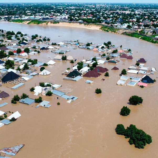
Impacts of Flash Flood
Flash floods have the highest mortality rate (defined as the number of deaths per number of people affected) among different classes of flooding (e.g., riverine, coastal). Flash floods are among the world’s deadliest natural hazards and have significant social, economic and environmental impacts.
Economic Losses
Depending on the damage caused, it may prevent local businesses from opening or keep customers from getting to those businesses.
Loss of Critical Infrastructure
Large debris and floodwaters can cause structural damage to bridges and roadways, making travel impossible. Power, telephone, and cable lines can be taken out by flash floods as well. Flood waters can disrupt or contaminate ground water, making tap water unfit for consumption.
Deposited Sediment & Silt
Flood waters carry along with them sand, silt, and other debris as they travel. When the velocity of the flash flood slows, it begins depositing this debris. Floods can leave behind large amounts of silt and other debris that can make travel difficult and can be costly to remove.
Immediate Property Damage
In addition to the force of the water, flash floods can carry large debris such as boulders. This combination can cause heavy structural damage to homes making them uninhabitable and can carry away large pieces of property such as vehicles.
Long-Term Property Damage
Rooms, vehicles, and other property that came in contact with flood waters may not be salvageable. Homes that were flooded can be susceptible to harmful molds. Vehicles that were submerged usually have irreparable water damage to the engine and other critical components.
Health Impacts from Flash Floods
The effects of flooding on health are extensive and significant, ranging from mortality and injuries resulting from trauma and drowning to infectious diseases and mental health issues (acute and longterm).
It has been reported that two-thirds of deaths associated with flash floods are from drowning, with the other third from physical trauma, heart attacks, electrocution, carbon monoxide poisoning and fire.
Morbidity associated with floods is usually due to injuries, infections, chemical hazards and mental health effects (acute as well as delayed) (WHO, 2013).
Hypothermia may also be a problem, particularly in children, if trapped in floodwaters for lengthy periods (WHO). There may also be an increased risk of respiratory tract infections due to exposure (loss of shelter, exposure to flood waters and rain).
Power cuts related to floods may disrupt water treatment and supply plants thereby increasing the risk of water-borne diseases as well as the proper functioning of health facilities, including cold chain.
Flash floods can potentially increase the transmission of the following communicable diseases: water-borne diseases (such as typhoid fever, cholera, leptospirosis and hepatitis A) and vector-borne diseases (such as malaria, dengue and dengue haemorrhagic fever,etc.).
The longer-term health effects associated with a flash flood are less easily identified. They include effects due to displacement, destruction of homes, delayed recovery and water shortages.
Prediction and Forecasting of Flash Floods
Predicting flash floods requires accurate detection and estimation of rainfall events, which are typically intense and very localised. Operational prediction methods include flash flood monitoring and prediction algorithms (FFMPA) used in Europe and the United States. FFMPA alerts forecasters when flash flooding is imminent based on radar-estimated rainfall amounts compared to hydrologic model-based rainfall thresholds.
Flash floods manifest and dissipate in less time and occur in more condensed spatial areas than river floods. These factors make their forecasting a unique challenge compared to traditional flood forecasting approaches.
In this regard, the World Meteorological Organization has launched the Flash Flood Guidance System (FFGS) with global coverage. A system such as the FFGS is an important tool for providing operational forecasters and disaster management agencies with real-time informational guidance products pertaining to the threat of small-scale flash flooding.
The FFGS provides remotely sensed precipitation estimates (e.g., radar and satellite-based rainfall estimates) and allows product adjustments based on forecaster experience with local conditions, incorporation of other information (e.g., Numerical Weather Prediction output) and any last minute local observations (e.g., non-traditional rain gauge data).
Mitigation of Flash Floods
Reducing societal exposure to flash floods is key to any mitigation measure. The combination of non-structural measures and small-scale structural measures could be more effective in managing flash flood risk.
Non-Structural Measures
There are many non-structural measures that can reduce the impact of floods such as land-use planning, building construction codes, soil management, acquisition policies, insurance and risk transfer, awareness raising, public information, emergency system and recovery plans.
Structural Measures
Structural activities including property protection such as relocation and reinforcement, and structural engineering projects such as levees, diversions, and channel improvements are some of the actions that mitigate the societal impacts of flash floods.
Flash Flood Hazard Measurement and Modelling
Flash flood hazard measurement and modelling requires a complex approach as more environmental factors must be considered and regularly monitored:
Topographic parameters (average slope, slope range and valley density for the catchment), soil and surface parameters (surface runoff, infiltration and interception: soil depth, physical soil type, the ratio of barren/ vegetation-covered surfaces), and hydrological parameters (precipitation, consecutive rainy days, etc.)